
Saves time — no need to wait for the sun's position to change. Measures light from five different zenith angles with one reading.

Sensor receives radiation below 490 nm only, where leaf reflectance and transmittance are minimal.
A diffuser cap is used for collecting ancillary data for applying scattering corrections when operating in direct sunlight.
Useful for measuring tall canopies using two sensors.
Any object that blocks the sensor's field-of-view by the same amount for both above and below-canopy readings will not influence the results. This allows, for example, measuring the LAI of grass beneath a tree as long as the tree is equally present in both above and below-canopy readings.
Allow LAI measurements of small plots and hedges by blocking undesired objects from the sensor's view, such as the operator or a neighboring plot.
View GPS coordinates, Leaf Area Index (LAI), standard error LAI, apparent clumping factor, mean tilt angle (MTA), standard error MTA, sample size, and more. Basic data processing is available directly on the console.
Add location information with each reading or log GPS data independently with GPS tagging.
Use the two BNC connectors for attaching LI-COR quantum, pyranometer, or photometric sensors.
Take advantage of automatic logging, USB data transfer, and a memory capacity of 1.5 million readings.

The GPS module generates the latitude, longitude, and UTC data used to determine solar position for light scattering corrections when operating under direct sunlight.
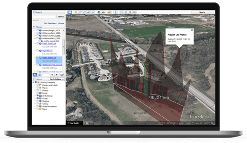
Each above or below-canopy reading can be paired with GPS data for that location. In addition, “tagging” logs GPS data for your location whenever a numbered key is pressed (1–9) while GPS is enabled. Using files containing GPS data, the FV2200 PC application generates KML files for viewing on Google Earth. Parameter choices include:
Continue Reading