Measuring meteorological parameters above hazardous terrain presents unusual challenges – especially when the terrain is dangerous to humans and unsuitable for infrastructure. Dr. Amir Aliabadi, Assistant Professor of Environmental Engineering at the University of Guelph in Ontario, Canada, overcomes these challenges by attaching instruments to a modern version of humanity’s first flying machine – a tethered air blimp.
While a tethered balloon might seem primitive in the world of drones and light aircraft, it is an ideal platform for taking measurements above active mines and tailings ponds. Tethered air blimps offer extended flight durations and there is no need to obtain permits to operate them in Canada.
“Tethered balloons are viewed as structures here in Canada. They're not even considered airborne devices since they are connected to the ground,” Aliabadi says. “As such, we are not required to obtain flight permits or pilot licenses to launch a tethered balloon. We simply inform local authorities… to obtain their approval to fly. They usually provide approval fairly quickly, making this approach very attractive for us to get a tethered balloon up and running in complex environments.”
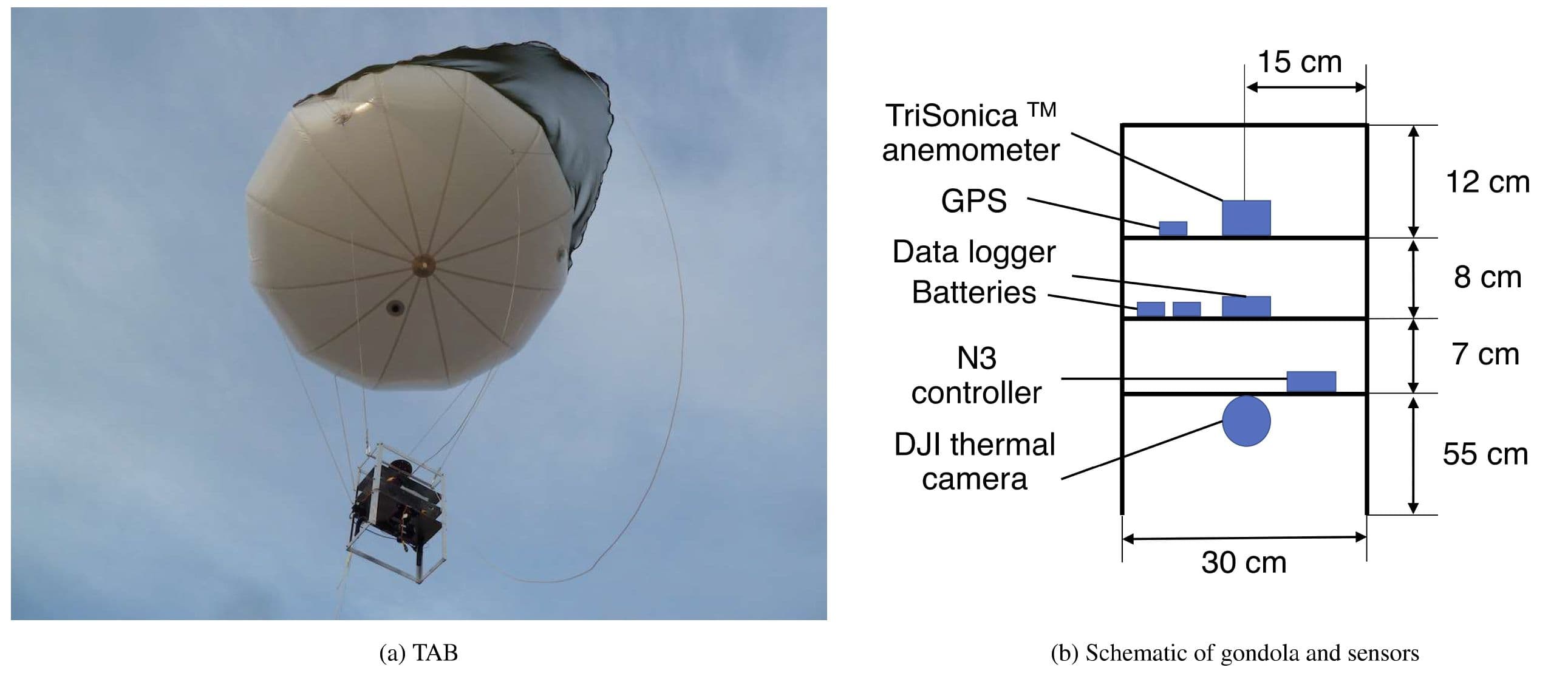
Aliabadi and his team equipped the balloon with a sensor payload that included devices to measure components of the wind velocity vector, temperature, relative humidity, pressure, and barometric pressure across the lowest 200 meters of the atmospheric boundary layer. The payload included a TriSonica® Mini Wind and Weather Sensor, which measured wind speed and air properties.
With its 35 mm measurement path length and weight of just 50 grams, the TriSonica® Mini is ideal for use with the tethered air blimp system. Low power consumption (30 mA at 12 volts) ensured that it measured wind for hours without depleting the batteries – a critical benefit given the team’s desire for extended flights. “Our balloon just lifts off and ascends-descends slowly and collects hours of data, which is what you need to do to perform a proper long-term assessment of boundary layer physics,” he says.
“While accuracy of measurements and weight were key factors in selecting the TriSonica Mini, the key element was the sensor’s price,” clarifies Aliabadi. “Competing ultrasonic anemometers can cost as much as $10,000 Canadian. The TriSonica Mini was a fraction of that cost and thus made the decision an easy one for us.”
In addition to capturing wind profiles, the TriSonica Mini accurately measured pressure and temperature. Aliabadi remarks that “those two measurements give you a very accurate elevation and we used thermodynamics, pressure, and temperature to determine the elevation of the sensor. We were able to do that within a meter, which was pretty amazing. If we had to use satellite data for elevation it is much less accurate. The TriSonica Mini did a very good job. It also allowed us to measure the stability of the atmosphere, thermal stability, heat flux, and so on.”
Results of the study, which is published by Geoscientific Instrumentation Methods and Data Systems (https://doi.org/10.5194/gi-9-193-2020), show that the tethered air blimp “offers a simple and cost-effective platform for microclimate measurements within the atmospheric surface layer. The light high-frequency weather sensor on board enables measurement of mean and turbulence statistics of the atmospheric meteorological variables. This configuration allows a wide spatiotemporal coverage compared to fixed flux towers.” He adds that blimps “can potentially provide meteorological data as boundary conditions or validation datasets for developing high-resolution computational fluid dynamics and other mesoscale models that attempt simulating meteorological processes and emission fluxes from large complex terrains of mining and other similar facilities.”
At a time when many are looking for ways to simplify the complex, Aliabadi and his students found an answer with a tethered air blimp – a modern version of the first flying machine.
Purchase Online
Get a Quote