Comparison of Multi-Rotor Drone-based Wind Sensing Platforms
Authors: LI-COR, Inc.
Correspondence: envsupport@licor.com
Published: 2024
Instruments: LI-550
Keywords: anemometer, drone, flight data
Abstract
Researchers who measure wind from UAV platforms have more options than ever. Several methods have been developed, and numerous sensors are available to take the measurement. In this document, we describe the differences between direct measurements with several models of on-board anemometers, and we describe differences between direct measurements and flight-data estimates.
1 | On-board anemometers
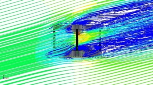
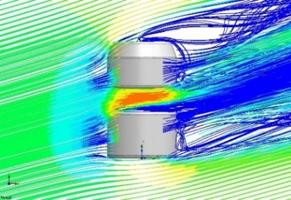
A comparison of LI-COR and FT Technologies onboard wind sensors is given in Table 1. UAV operators should consider the physical aspects of the sensor, including size and weight, power requirements, communication options, and the measurements reported by the sensor. A visual representation of flow distortion is given in Figure 1.
2 | Flight-data estimation algorithms
Flight-Data Estimation algorithms use post-processing techniques to estimate wind forces acting on the drone. These techniques use drone navigation, accelerometer, and rotor response inputs to calculate wind speed and direction. Mathematical techniques applied include Tilt, Kalman Filtering, Machine Learning, System Identification, and Dynamic Modeling.
2.1 | Methods
Meier et al., (2022) provides a retrospective review of drone wind-estimation techniques and features an extensive bibliography on the subject matter. Summarizing the need for improved technique, Meier et. al, explained:
"The tilt method correlates the drone’s attitude to wind speed during hovering.…All other methods are model-based and thus define a more or less generic or complex systems and estimate the model parameters using various methods such as machine learning, system identification, or filtering. Data used for parameter tuning may be produced by simulation, wind tunnel tests, or field tests. Most of the listed methods assume a stationary drone. Finally, all listed publications but one do not estimate vertical wind or may even assume it to be zero. Such an assumption is generally valid as vertical wind typically has a small effect on the drone relative to the horizontal wind, thus it can be removed as an unknown in model-based approaches without significant consequence."
Meier et. al, emphasizes the limitations of these methods, including limited application in real-world scenarios, the assumption of a stationary drone, and lack of estimation of vertical winds, and goes on to propose a “Dynamic Model-Based Approach”.
This approach assumes “that thrust can be measured or estimated, while drag can be related to air speed.” Meier et. al, claims that this method provides “precision and accuracy comparable” to tilt-method estimations for drone-hovering scenarios and can also “estimate wind while the drone is moving.”
Advocates of a similar approach presented at a recent International Society for Atmospheric Research using Remotely piloted Aircraft (ISARRA) conference (Bramati et al., 2003).
2.2 | Differentiation between onboard and flight-data methods
The ISARRA conference included representatives of both methods, and there remains a lack of consensus on which is the “best” method. Several of these methods remain yet unproven in real-world applications. The answer for which is best will likely depend on the particular interests of the observer.
While the Flight-Data method does not require the attachment of additional equipment, it does require an understanding of the drone motor and rotor blade configuration. Meteomatics’ Meteodrones are designed to have a consistent build configuration allowing for certainty of performance in these areas.
Audience members at that conference also pointed out that the estimated wind values obtained using Flight-Data methods cannot supply high-speed data suitable for use in assessing gas plumes and similar phenomena. The results provided are relatively coarse estimates of the wind behavior at the point of the drone. This allows for a broad characterization of conditions such as wind shear and trends aloft. In some ways, these results can be compared to the utility of propeller or cup and vane anemometers – accurate and easy to deploy, but not suited to identify fine-scale changes in near real time.
Onboard methods can obtain high-speed direct measurement of actual wind phenomena, but results can vary depending on the location of the mounting system relative to the rotor wash. Again, depending on the setup, these direct measurements can be transmitted to a base receiver in near-real-time. Best results are obtained when the drone has hovered for a time in the place of desired measurement; however, obtaining measurements is still possible while the drone is in motion by using drone GPS data to inform post-processing calculations. This high-speed direct measurement is useful for measuring gas plumes and ground-truthing other time-sensitive environmental observations, such as fire weather behavior, wind-and-structure interactions, below-canopy conditions, and eddy covariance flux footprints.
| Onboard Method | Flight-Data Method |
|---|---|
| Direct Measurement | Estimation |
| Near-Real-Time Possible | Post-Processing Only |
| High Speed Measurement Possible | Accurate but Coarse Measurement |
| Drone requires additional sensor | No additional sensor required, less expensive |
| More than 5 years real world applications | Many algorithms still in the testing stage |
| Suitable for time-sensitive observations | Broad Characterization after observation |
3 | References
| 1 | Bramati M, Savvakis V, Schön M, Platis A, Bange J. Analyzing Horizontal and Vertical Wind Speed Suing Multirotor UAS Aircraft: Calibration, Environmental Factors, and Accuracy Assessment, ISARRA 8th Conference, 2023. |
| 2 | Gebauer J, Bell T, Segales A, Smith E. Using Optimal Estimation for Retrieving Winds from Multirotor UAS, 8th ISARRA Conference, August 2023. |
| 3 | Kistner J, Wildmann N. High Resolution Wind Vector Measurements with Quadcopters: Calibration and Verification in a Wind Tunnel with Active Grid, 8th ISARRA Conference, August 2023. |
| 4 | Meier, K., Hann, R., Skaloud, J. and Garreau, A. (2022). Wind Estimation with Multirotor UAVs. Atmosphere, 13(4), p.551. doi: https://doi.org/10.3390/atmos13040551 |